| The Trundle |
| Map Ref : SU877111 |
| Subject List | History | Archaeology | Folklore |
|---|---|---|---|
|
|
| Name Derivation |
|
THE TRUNDLE: From Tryndel (OE circle) Orig. Trendle (1500 SNQ Vol. 3 p.151) Notes: The Trundle is the name of the hillfort crowning the hill, though its name, meaning a circle, is actually a misnomer as the fort is built of several straight sections. In addition to this, Curwen (1929 p.35) gives us the name Billingabyrig from an early Saxon document, which he considers may apply to the hillfort, and would, if it had survived, have become Billingbury. ST. ROCHE'S HILL: Orig. St. Rokeshill (1579), St. Rookeshill (1610), Rowkeshill (1650), St. Rocks Hill (1675), Rook's Hill (1725) Notes: St. Roch was a French Saint, a chapel to whom was built on the hill (Mawer & Stenton 1929 p.54). |
|
| History |
|
Introduction
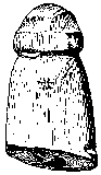
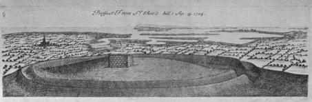
St. Roche's hill in West Sussex is a lone hill that rises to 206 feet and commands an excellent view all round. The hill is famous for the Iron-Age hillfort on its summit, called the Trundle, which has also caused the hill itself to be named 'Trundle Hill'. The history of the hill can be traced back to the Paleolithic, as will be seen from the section on archaeology, but successive generations have built on the hill for one reason or another. Before the hillfort was a Neolithic Causewayed Enclosure, whilst following the construction of the Iron-Age hillfort, the hill was occupied, probably into the Romano-British period. More modern buildings include a chapel and a windmill, both now gone, leaving a pair of radio masts to take advantage of the height of the hill. It is not known whether the hillfort was used defencively at the time it was built, but the hill was used by the Clubmen in the 17th century and as a beacon site to warn against attack (Haines 1880 p.152) by the French, which was lit in 1745, causing much alarm in the surrounding countryside. The parish boundary of Lavant and Singleton heads East-West past the camp, heading around the south side of the rampart before heading of on its previous course. There is good evidence that this boundary goes back to at least 725CE, when it is mentioned in a charter where Nunna, King of Sussex grants land to the Bishop of Selsey (Curwen 1929 p.34). The Clubmen In 1645, a large number of the political movement known as 'The Clubmen' used the hill as a military base. The clubmen used commoners weapons and fought both the Royalists and the Parlimentarians when they came to plunder the lands of the common people. It is recorded that there was "divers outrageous proceedings of 1000 Clubmen at Rowkeshill", though they dispersed back to their homes after they heard that the Hampshire Clubmen had been defeated near Winchester by the Parlimentarians (Arnold 1886 p.29). The Chapel St. Roche's Hill takes its name from the chapel dedicated to the saint that used to stand on the summit of the hill. It was around 11 feet by 14 feet and would have been mostly destroyed during the reformation, the drawing below showing what was left in 1723 (Curwen 1931 p.187). St. Roche was a 14th century French saint, meaning the chapel had to have been built sometime after that date. The chapel was already a ruin in 1570 (Allcroft 1916 p.76).
The Windmill A windmill once took advantage of the height of St. Roche's Hill to get a good wind. It is not known when it was built, but in 1773, the windmill burnt down in a storm, along with a windmill on Ports-Down (Haines 1880 p.156). It is generally assumed that this was caused by lightning, but this is not mentioned in the account of the fire. Whilst it is possible that both windmills were struck by lightning, it is more likely that friction internal to the windmill caused the fire, especially as the account mentions a 'storm of wind'. Such an end was common for windmills. The windmill apparently occupied the site of both the Beacon and the Chapel of St. Roche (Curwen 1931 p.187). The Masons Though it is no longer in existance, there was once a Masonic Lodge on the Trundle. The Duke of Richmond set up the lodge there on his land in 1730, though other records claim the lodge was "Constituted in the reign of Julius Caesar", further stating that the members "met once a year Tuesday in Easter Week" (Dixon 1974 p.19). |
|
| Archaeology | |||
|
The Paleolithic
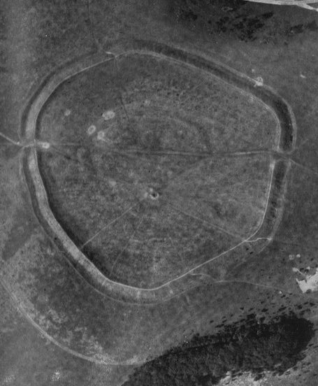
Back in the Paleolithic, the sea came to near the bottom of the hill, but as the ice sheets pressed down on the north of Britain, the south was pushed into the air, leaving old beaches high and dry. These 'raised beaches', when the sea was still there, were often frequented by Paleolithic peoples, the most famous case in Sussex being at Boxgrove, just to the South-East, where a human bone a half a million years old was found along with crude flint implements. Flint finds from the Paleolithic have also been found in "Raised Beach Deposits" at or near "the foot of Trundle Hill". The fifty artifacts found were mostly handaxes (Roe & Holden 1968 p.211). The Neolithic Causewayed Enclosure Within the confines of the Iron-Age hillfort on St. Roche's hill, and partly overlain by it, is a Neolithic Causewayed Enclosure. These monuments are the first enclosures built in England and seem to have provided a range of functions from the sacred to secular. They are constructed by digging sections of ditches, usually in concentric circles, with small causeways in between, throwing the earth inwards to form a low bank. The Neolithic causewayed enclosure on the summit of St. Roche's Hill was discovered by OGS Crawford in 1925 when he saw the enclosure on arial photographs. He informed Curwen who dug for two seasons (Curwen 1929,1931), excavating several ditch segments on the western side of the enclosure, as well as a single ditch segment on the outside of the Iron-Age rampart to the north, where the enclosure met the rampart. A small excavation was also carried out on a neolithic ditch section in 1980 by Bedwin & Aldsworth. The enclosure itself is quite large for Sussex, with only Whitehawk being a comparable size. The picture is however rather confused by the layout of the enclosure. The inner enclosure has a more continuous bank than the other sections, but just as many separate ditches and causeways. The inner enclosure has also survived the best to the present day, and can be traced on the ground as a low bank. From here on in, things are not quite as clear. Curwen's original plan, shown below, suggests a single spiral ditch, which winds its way outwards, and this is the interpretation that has been accepted until recently. The recent survey of the hill by the RCHME, now a part of English Heritage, has shown that this interpretation is complicated by additional enclosure sections not noticed before. Firstly, there appears to be a second almost concentric enclosure around the first, which is what you would expect from a normal causewayed enclosure, but there are several non-concentric enclosure sections that appear to spring from, or join to, this second enclosure, some of which cross eachother on their eccentric orbits around the central enclosure. There is also one, and possibly two sections outside of the Iron-Age hillfort. The first being an arc on the north side, which exits from under the rampart and disappears under it again. The second possible section is in fields on the west side, where a soil mark could possibly represent an extension of a section of the enclosure, though it could also be come sort of linear earthwork used as a land boundary (Bradley 1969 p.133).
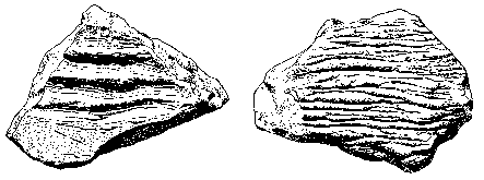
The ditch sections excavated, mostly by Curwen, contained mostly flintwork, animal bones (ox, pig, sheep and roe deer) and Neolithic pottery of the "Windmill Hill" type, showing a cultural connection with the west, Windmill Hill being a causewayed enclosure near Avebury in Wiltshire. The flintwork consisted mostly of waste flakes, and flint knapping most likely took place here. A few rough, unfinished, tools were found with the flakes along with plenty of cores.
The less numerous objects included pieces of quernstone and grain rubber, two pointed bone tools, probably used for pressure flaking of flint, and a piece of bone, sawn through on one end and carved into the shape of a phallus on the other (Curwen 1929 p.56). As with other neolithic sites, carved chalk objects were found, including three chalk cups, most usually seen in flint mines, five pieces of chalk perforated by large holes, and four flat pieces of chalk with incised lines, a common but little understood motif (Curwen 1929 p.61, 1931 p.143,Bedwin & Aldsworth 1981 p.211) The Bronze-Age Little seemed to have happened in the Bronze-Age on St. Roche's Hill. Analysis of land snails suggest the area became overgrown after the abandonment of the causewayed enclosure, only being cleared again in the Iron-Age (Bedwin & Aldsworth 1981 p.209). Nevertheless, the RCHME survey suggests the mound upon which the windmill and chapel stood was initially a Bronze-Age round barrow, on the strength of the surrounding ditch. They also suggest that Curwen's 'covered way', which points towards the barrow from the South-East but seems to stop at the rampart, is contemporary with this, being of an earlier date than the Iron-Age rampart (Oswald & McOmish 1995 p.22. They also suggest that two linear earthworks, or cross-dykes, on spurs to the north of the hillfort are also Bronze-Age, once of which contained a crouched burial (Oswald & McOmish 1995 p.15). Bradley (1971 p.20) identifies a road leading northwards from the eastern dyke with fields around it, suggesting the dyke was constructed to keep livestock away from the fields. This suggests a permanent settlement in the vicinity, the obvious choice being the Iron-Age Trundle, given the lack of any solid evidence for a Bronze-Age settlement. The Iron-Age Hill-Fort 'The Trundle' is the name of the Middle Iron-Age hillfort on the summit of St. Roche's hill and is one of only four forts built in Sussex during this part of the Iron-Age. It's name is Old English for 'circle' or 'hoop' but the ramparts are actually built of around 9 straight sections and encloses 5.66 hectares of land (Hamilton & Manley 1997 p.103). There are two opposing entrances at roughly ENE and WSW, which would have held wooden gate structures.
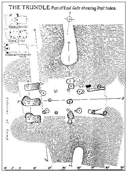
Not much of the hillfort itself has been excavated, though sections within it relating to the causewayed enclosure have. The white spots on the arial photograph above show the locations of some of Curwen's 1928 excavations, which included a large pit near the western gate and a small section of the rampart where it overlayed the causewayed enclosure (Curwen 1929 p.33). Curwen later returned to the hillfort and excavated the east gate (Curwen 1931 p.100). Various other pits were opened were opened within the ramparts that proved to be Iron-Age in date, some of which cut into the ditches of the causewayed enclosure, which was levelled to a degree as part of the Iron-Age occupation. The rampart is on average 1.8 metres in height and as has already been mentioned, was built in a series of straight sections. The excavation of the rampart on the north side revealed nothing of an Iron-Age date, though a section of the causewayed enclosure was excavated underneath. The eastern gateway however, revealed more in the way of dating evidence.
Curwen (1931 p.118) suggests the series of postholes he excavated represented three separate set of gate structures. The first a double gate in line with the rampart, the second a series of smaller gates, the third, represented by the three largest pits were apparently never used, representing an unfinished improvement to the defences of the fort. Several pieces of La Tene pottery (Middle Iron-Age) were associated with these gate structures, along with evidence that the rampart near the gates were reveted with flints. Of the other pits excavated, the largest was near the west gate, and probably represents part of a gate structure similar to the large post pits excavated at the east gate (Curwen 1929 p.43). Within the hillfort, several other pits were found (Curwen 1929 p.41,Curwen 1931 p.111), which like the gate potholes, had been hollowed out with metal adze's and antler picks. The contents of the pits included Middle Iron-Age pottery, potboilers, human bones (an arm bone and a skull), animal bones (ox, horse, pig, dog, cat and sheep), charcoal, various iron objects (including a knife, a spearhead, an adze blade, a sickle, large iron rings and Iron-Slag) and several quern fragments, which Curwen notes had been broken intentionally. Whilst Curwen classifies these pits as cellars and rubbish pits, it may be that they are similar to the 'ritual' pits found at Mount Caburn, another Middle Iron-Age hillfort in East Sussex (Hamilton & Manley 1997 p.103). Of the finds of animal bone, it is interesting to note that some of them were perforated, as if for suspension. These included a sheep bone and a boar's tusk. Roman Times And Later As with the Bronze-Age, there seems to have been little activity on the hill, though the RCHME survey identified several possible rectangular hut platforms, which may date to Romano-British times. They also identified a few pieces of Romano-British pot, which goes some way to prove there was settlement on the hill at this time, though it was probably not as extensive as the Iron-Age occupation (Oswald & McOmish 1995 p.25). |
|
| Folklore |
|
The Devil And The Golden Calf
There is a piece of folklore concerning the Trundle regarding the Devil and Buried Treasure. The most common version goes something like this : In the Down there's a golden calf buried; people know very well where it is - I could show you any day. Then why don't you dig it up? Oh, it's not allowed; he wouldn't let them. Has anyone ever tried? Oh yes, but it's never there when you look; he moves it away. (Parish & Hall 1957 p.30) He of course is the Devil, who the Sussex people avoid saying the name of by using the word He with a special emphasis. Despite the warning in the above passage, Simpson (1973 p.24) tells a story of an attempt to dig up the Golden Calf from it's resting place : You know there's many a one tried... My Dad used to say as his grandfather got up early on Holy Sunday an' went along to the place an' started digging. An' he actually ketched sight of a lump o' gold, an' then he was almost deafed by a clap o' thunder, an' when he looked again, the gold was gone. Simpson also records that the calf was known as 'Aaron's Golden Calf', which may give a clue to the origin of this particular piece of folklore. Jeremy Harte (pers. comm.) has suggested some buried treasure folklore may have come about during the Reformation, when it was thought that Catholics buried or hid the valuable church objects rather than having them stolen by the reformers. This certainly makes sense for the Trundle with its shrine which was probably destroyed during this period, with the reference to Aaron's Golden Calf bringing to mind the Protestants criticism of the Catholics, that they were obsessed with excessive wealth and decoration in their worship, which of course was also linked with the Devil. Simpson mentions another version of the above tales, which doesn't mention the Devil at all, and where the Calf isn't Golden. It is said that a Viking raiding party stopped at the Trundle to hide some treasure before they headed west to fight the men of Chichester in Kingley Vale, leaving a ghostly calf to guard the treasure. The Vikings were defeated, leaving the treasure where they buried it, with the ghostly calf being heard crying in the woods of Goodwood. A connection with the previous story is given with the explanation that there was supposed to be enough treasure to make a Golden Calf (Crosby 1927 p.535). Construction Folklore Echoing the above piece of Viking folklore, it is recorded in 1804 that the construction of the Hillfort itself is also ascribed to the Vikings though Horsefield in 1835 gives another local tradition that the fort was raised by a Roman Army (Oswald & McOmish 1995 p.5). St. Roche The existence of the chapel of St. Roche (Roch?) on the top of The Trundle is probably quite significant. The saint was associated with the control of the weather, which was thought by some to originate on the tops of hills, so the chapel may have been used to pray for good agricultural weather for the surrounding countryside. It is also interesting to note that the saint also protects animals. Perhaps he is protecting the golden calf in the hill, and perhaps the legend of the golden calf is due to the existence of the chapel (Wilson 2000 p.83,94). |
|
| Bibliography |
|
Allcroft, A.H. : Some Earthworks of West Sussex, SAC Vol. 58 1916 Arnold, F.H. : Cawley the Regicide, SAC Vol. 34 1886 Bedwin, O. & Aldsworth, F.G. : Excavations at the Trundle, 1980, SAC Vol. 119 1981 Bradley, R. : The Trundle Revisited, SNQ Vol. 17, No. 4 1969 Bradley, R. : Stock Raising and the Origins of the Hillfort on the South Downs, Ant. J. Vol. 51 1971 Crosby, L.T. : Treasure Trove in South-West Sussex, SCM Vol. 1, No. 12 1927 Curwen, E.C. : Excavations in the Trundle, Goodwood, 1928, SAC Vol. 70 1929 Curwen, E.C. : Excavations in the Trundle, Second Season 1930, SAC Vol. 72 1931 Curwen, E.C. : St. Roche's Chapel, Goodwood, SNQ Vol. 3, No. 6 1931 Curwen, E.C. : Sussex from the Air, SCM Vol. 5, No. 1 1931 Dixon, H.R. : The History of Freemasonry in Sussex, Carmichael 1974 Haines, W. : Spershott's Memoirs of Chichester, SAC Vol. 30 1880 Hamilton, S. & Manley, J. : Points of View: Prominent Enclosures..., SAC Vol. 135 1997 Mawer, A. & Stenton, F.M. : The Place Names of Sussex (Parts I & II), Cam. UP 1929 & 1930 Oswald, A. & McOmish, D. : A Causewayed Enclosure and the Trundle Hillfort on St. Roche's Hill, RCHME 1995 Parish, W.D. & Hall, H. : A Dictionary of the Sussex Dialect, Gardners 1957 Roe, D.A. & Holden, E.W. : Two Recently Discovered Lower Paleolithic Handaxes..., SAC Vol. 106 1968 Simpson, J. : The Folklore of Sussex, Batsford 1973 Wilson, S. : The Magical Universe, Hambledon and London 2000 |
[ Sussex Main Page ]
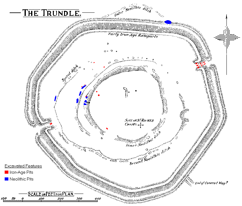 Curwens Plan of The Trundle