| Mount Caburn |
| Map Ref : TQ444089 |
| Subject List | Archaeology | Folklore |
|---|---|---|
[ Sussex Main Page ]
|
|
| Name Derivation |
|
CABURN : Perh. From Caer Bryn (Welsh - Stronghold hill) More Likely Calde burgh (Old English - Cold Fort - 1296) Then. Mount Carbone (late 18th century) Traditionally Pronounced Cawburn, given as The Caburn without the usual Mount prefix. GLYNDE : Perh. From Glind (fence or enclosure) Orig. Glinde (1210) then Gline (1587) RANSCOMBE : From Rams (Sheep) and Combe (Valley) Orig. Rammescombe (1291) then Rambscombe (1590) then Ramscombe (1823) Note Ranscombe Camp is named after the farm just below of the same name OXTEDDLE BOTTOM : Perh. From Oxena (Saxon for cow), Saetum (Saxon for stalls) and Bottom (Valley) Orig. Oxenceton (1541) then Oxsettle (1799) |
|
| Archaeology |
|
Introduction
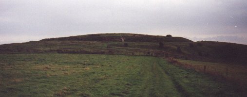
Mount Caburn is a peak on a small isolated part of the Downs separated from the main bulk of the Downs by valleys cut by the River Ouse and it's tributaries. The area overlooks the county town of Lewes and is just west of the village of Glynde. Mount Caburn itself is host to an early Iron Age fort at it's highest point, enclosing about three and a half acres. The ground falls steeply in all directions except on the forts north side where the walls are stronger. The walls would have been surmounted by a stockade and was a site of permanent residence rather than somewhere to stay in the event of invasion. It was used this way from approximately 500BC to 100AD, around the time of the occupation of the Romans, when the new peace they brought meant living in protected hill-top forts was no longer necessary.
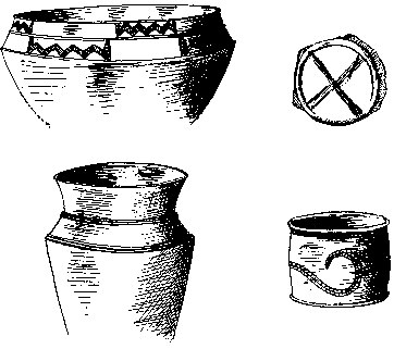
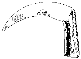
Chronology Pollen samples have shown that the area around Caburn Hill was covered by dense woodland, probably yew, until the bronze age when the area was cleared. There are several bronze age burial mounds in the area and there is evidence for the use of Mount Caburn itself in the Bronze Age as the site of an open village which continued into the Iron Age until 100BC when the Iron Age fort was built. After the initial Bronze Age settlement but before the ramparts on Mount Caburn were built, the incomplete Ranscombe Camp to the west was started and reused later as a Romano-British Settlement around the second century AD. Changes in styles of pottery found in the camp suggest that more than one culture used the fort in the Iron Age and after the initial fortification of Mount Caburn, the banks were re-fortified later with more ramparts on the north side. Post holes have been found in the gate area and it is likely the ramparts were surmounted by a stockade, though because of the nature of the hill the fort is built on, it would have been possible for people at a distance to see the village inside the stockade rising above on the hill inside. There have been Roman coins found in the area though the fort was falling out of use during the time of the Roman occupation. After the camps lack of use during part of the Romano-British period, there is evidence for Saxon use of the site, probably around the time of the Saxon invasion as the influence of Rome in Britain waned. Further still, a Norman cooking pot found in a hearth has been found and the camp was later used as a lookout post for Lewes Castle. Settlement Signs of buildings themselves are limited, being restricted to unbaked clay used as wattle on the walls of huts and possible post-hole evidence for two huts found in 1930 which seem to date from before the ramparts. Further pre-rampart evidence suggests this settlement was surrounded by a pallisade enclosure. It was a small settlement, the site is only about 3½ acres in size with an entrance to the north-east. The site is covered with around 140 pits used for storage, refuse or perhaps ritual which were excavated by Lane-Fox in 1881 and Dr. Curwen in 1925. The objects found in them tell us something of the life of the people at the time. Evidence for the settlement in Bronze Age times or perhaps the first phase of building during the Iron-Age, was found by Lane-Fox under the outer northern ramparts, where small postholes were found with wattling for hut walls, one piece of which had the indentation of a post of the same size of the postholes found. This could have been a hut built during the Iron-Age before the second, outer rampart was built, but this raises the question of why there is evidence of Iron-Age habitation outside the fort but so little inside. Additionally, the only Iron-Age pottery found in or under the rampart is on the inside where the ramparts have collapsed inwards covering pottery lying on the surface. The rest of the pottery found in relation to the ramparts, both on the old land surface and in the fill of the rampart, is Bronze-Age. This is not the case with the outer rampart to the north, where Iron-Age pottery was found on the old land surface under the rampart. Further excavations in 1996 by Peter Drewett and Sue Hamilton confirmed the presence of two Late Bronze-Age/Early Iron-Age huts under the rampart. Archaeological Finds Preserved dog droppings containing bones showed the people here kept dogs as pets (a dog bone was also found at the bottom of the largest pit). We know that weaving was done here from the perforated chalk blocks used to keep the threads taught and to spin the thread tight and weaving combs made from deer antler were also found. Bronze and then iron were probably smelted as broken crucibles and refuse metal was found. Other iron objects include a sword (250BC-100BC), a dagger, a razor, some knife blades, a safety pin, a plough point, a piece of iron scale armour, an iron celt (axe blade) and a sickle or bill hook. A lead weight, indicating there might have been trade through here was also found, the weight being similar to what is supposed to be the celtic standard unit of measure.
Apart from the weapons mentioned above, several hundred beach pebbles were found, presumably used as sling stones, along with a sling bullet made of clay, as Cæser described the Gauls as using. The inhabitants traded using coins, probably brought over from Europe by invaders fleeing the advancement of the Roman Empire at about 50BC. They were made from an alloy of copper and tin and seem to have been copied from a Gaulish copy of a Greek coin depicting the head of Apollo on one side and a horse or bull on the other, the original Greek design having been reduced to a set of Stylised lines by several generations of copying. Also found was a Phoenician coin from Carthage (around 200BC) depicting Persephone on one side and a horse on the other, a relic of trade from far away. Phoenicians traders were one of the peoples put forward as the creators of the Long Man of Wilmington. Several other coins not contemporary with the site from the Roman period onwards were also found. The lead weight, almost a 16th of the Celtic pound was probably used for measuring for trading using some of these coins. Other items found include Luxury items such as a bronze brooch (50AD-100AD), a glass bead, and a finger ring.
A large quantity of pottery was found with a cross scored on the bottom, a mark most commonly found in bronze age pottery. It seems to perform no practical or decorative purpose, perhaps it is a superstitious mark similar to the Celtic Cross, designed to avert bad luck. Most of the pottery found was Iron-Age, though pieces of what seem to be coarse Bronze-Age pottery were also found in some of the pits, as well as what may be part of a bronze sword.
All of the objects found were in around 140 pits dug within the camp. In 1998, Sue Hamilton suggested that these pits were not random rubbish pits but could be votive offerings or ritual pits. Cited as examples are single human bones placed with wild animal bones in the same pit, a quern stone which has been broken and distributed between different pits, perhaps in the manner common in votive offerings at that time and the metal objects which were a common item to find in ritual depositions in rivers and bogs. A lot of these special finds seem to be clustered around the large pit on the north side of the fort which a 35 feet wide basin surrounding a 3.3 metres deep shaft. The shaft itself was quickly backfilled after being dug though some earth which was left over was thrown in a cresent to the north. Its construction is similar to that of standard wells dug in the Romano-British period, with a cone at the top with the shaft being cut lower down. The sides of the cone would have been filled up as the well was lined above the shaft, leaving a vertical serface, though this stage didn't happen at The Caburn. There were some animal bones such as pig, ox, rabbit and oyster in the soil above the backfilling, but the shaft itself contained very little, with only a single piece of Iron-Age pottery, an iron clinker (containing the remains of charcoal) and a piece of dog bone being found at the bottom. The meaning of these pits is unclear but pits and wells did have a ritual significance in prehistoric times. Some of the other pits in the camp seem to have been deliberately backfilled with chalk rubble rather than silting up naturally and according to Lane-Fox (Pitt-Rivers) who first excavated these pits, the excavated chalk rubble used to backfill the pits after the artifacts were deposited in the bottom, was thrown in from all sides, as the largest blocks were found in the centre. According to the Curwens analysis of the pottery found, these pits were used throughout the Iron-Age period and the life of the camp. Bones found in these pits were from Ox, Pig, Horse, Goat, Sheep, Roedeer, Badger and birds. 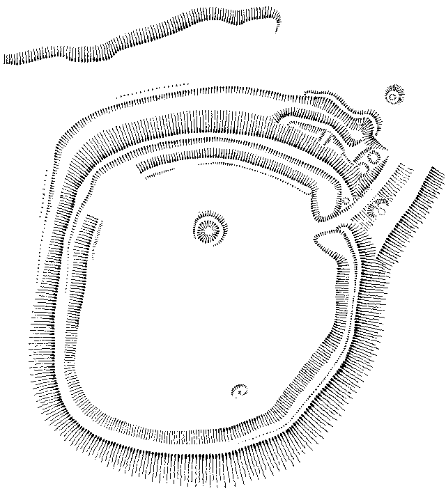
Oxteddle Bottom There is a valley to the north-west of the Caburn called Oxteddle Bottom. There are earthworks here, not marked on the map, which along with the name suggests some sort of building used to house the teams of oxen that were used to work the fields in Sussex. Through the valley a track runs east-west and the earthwork sits around this, with a slight slope to the south for drainage. Following the path to the east you come to another valley called Bible Bottom which has another earthwork shaped like a book which the path runs through, which may indicate stalls of a similar kind. Other examples of this type of earthwork have been found in Sussex, the only other surviving example being in Faulkner's Bottom southwest of Plumpton, marked on the Ordnance Survey maps as an Enclosure. This earthwork has a road running through the middle and may suggest the example in Bible Bottom also had a similar use, the Hubbards in their "Neolithic Dew Ponds and Cattle Ways" suggested the structures were cattle counting houses and that there was also a similar example at the Devil's Dyke (The book was published in 1916 - 3rd Edition). Ranscombe Camp Ranscombe Camp is a bank and ditch that runs along the south and east edges of a rise to the west and on the same spur that Mount Caburn sits on, the north and west of the camp being either unprotected, plouged out or uncomplete. Its position as a fort is inferior to that of Mount Caburn with a slight dip in between the two and it has been suggested that it was constructed by the Romans as they were attacking the fort to the east though this has been proved false by excavations in 1959 which provided some datable pottery. The earliest pottery found relating to the camp was Early Iron-Age (with a small amount of Bronze-Age pottery on the old land surface under the ramparts) and similar to that found on Highdown Hill which would suggest that the camp was constructed earlier than the fortification on Mount Caburn (Middle Iron-Age), though after the Bronze Age settlement that preceeded it. Later Romano-British pottery (including Samian Ware) and Roman tile also suggests the site was re-used in the second century. Evidence of heavy fortification was found in the existing bank with a double row of post-holes, roughly 6 feet apart. In the bank was also found the skeleton of a six month old baby surrounded by wood ash, the layer it was found in suggesting it was buried during the Iron Age. It looks like the camp was left incomplete though if it was completed then it would have taken in an area of a similar size to Cissbury Ring, though some think it was a "Cross-Dyke" type feature which was never meant to be an enclosure. The Caburn Landscape The section of Downland that Mount Caburn is part of has been cut off from the rest of the Downs by the River Ouse to the west and Glynde Reach, a tributary of the Ouse, to the south. The most common antiquities apart from the hillforts of Mount Caburn and Ranscombe Camp on this range of hills are barrows and field systems. Most of the barrows are bronze age and on the eastern spur though there is a Neolithic Long Barrow to the far north-west on Cliffe Hill and possibly two others to the north east. One of the Bronze Age barrows in the area, on Cliffe Hill above Lewes was excavated in 1930 before the quarry there destroyed it. The barrow was roughly 50 feet in diameter and contained several cremations topped by a cairn of flints and contained evidence of a cremation fire. A similar barrow is on the hill just north of the Caburn and a diary entry from about 1820 records the opening of other barrows in the area which yielded urns, beads and weapons. Most of the barrows are now unfortunately either ploughed out or plundered by 19th century 'antiquarians' who didn't record their finds. From soil analysis, it seems that some of the Bronze age barrows were constructed around the time of tree clearance on the hills, perhaps even the clearance was done to allow the construction of the barrows. Possible ritual use of the barrows is hinted at with finds of a substantial quantity of pottery just under the surface of a barrow on Glynde Hill which is part of the eastern spur of this section of downland. This use of the barrow after it has been constructed may be an indication of some sort of ancestor worship. The the valley area in the centre of the range of hills there is evidence for the keeping of cattle with cultivation of the steep slopes around. This area was probably chosen because of its sheltered position while not liable to flooding as the plain around Lewes and the River Ouse was. |
|
| Folklore |
|
Gil The Giant
A Giant by the name of Gil is said to have walked the slopes of mount Caburn, hurling his hammer from the summit. This aggressive image may be a distant memory of another local tradition, that a battle occured in the area. A nearby barrow that once stood on the site of the chalk quarry near Glynde railway crossing, was called 'Gil's (or Gill's) Grave' and stood amongst other barrows (containing Iron knives and rough pottery) on the rise just south of the stream now known as Glynde Reach. A Roman road has been traced crossing the stream at this point and once passed the barrow. Other places bearing the giants name include Gil's Ridge near Crowborough and Gil's Lap in Ashdown Forest. Another interpretation of the hammer throwing aspect of the legend hinges on the fact that it is not known what the giant in the story is throwing his hammer at. It may be a similar story to that of the giant Bevis who throws his sword to mark where he should be buried. Thus the site of 'Gil's Grave' in folklore could have been chosen by the same means as 'Bevis's Thumb'. Buried Treasure And The Devil There are two separate legends of Buried Treasure on the Caburn, a silver coffin and a knight in golden armour. The Caburn itself is said to be one of the clods of earth thrown afar as the Devil was digging the Devil's Dyke, other fallen clods are said to have made Chanctonbury Ring, Cissbury, Rackham Hill and the Isle of Wight. The Devil is also said to be responsible for an earthwork in the valley known as Bible Bottom, variously known as the Devil's Book or The Bible on Ordnance Survey maps, so called because the rectangular banks subdivided by a faint line resemble a book. |
|
| Bibliography |
|
A.J. & G. Hubbard : Neolithic Dew Ponds and Cattle Ways, Longmans, Green & Co. 1916 Allcroft, A.H. : Field Ox-Stalls in Sussex, SNQ Vol. 1 (65-70) 1926-1927 Allen, M.J. : The Prehistoric Land Use..., SAC Vol. 133 (19-43) 1995 Biggar, J. : Fieldwalking at Glynde near Lewes, SAC Vol. 122 (214-216) 1984 Burstow, G.P. : Excavations at Ranscombe Camp, SAC Vol. 102 (55-67) 1964 Burstow, G.P. : The Prehistory of the Caburn, SCM Vol. 15, No. 7 1941 Butler, Chris : Bronze-Age Barrow at Round-The-Down, SAC Vol. 133 (7-18) 1995 Coates, R. : Studies and Observations on Sussex Place-Names, SAC Vol. 118 1980 Croix, Rev. W : Parochial History of Glynde, SAC Vol. 20 (47-90) 1868 Croix, Rev. W : On a Vessel Found Near Glynde, SAC Vol. 23 (82-84) 1871 Currey, Bernard : Note on the Examination..., SAC Vol. 64 (189-190) Curwen, E.C. : Prehistoric Sussex, Homeland Association Ltd. 1929 Curwen, E. : Excavations in the Caburn, Near Lewes, SAC Vol. 68 (1-56) 1927 Curwen, E.C. : The Caburn: Its Date and a Fresh Find, SAC Vol. 72 (150-155) 1931 Curwen, E.C. : The Old People of Mount Caburn, SCM Vol. 1, No. 1 1926 Drewett, P. & Hamilton, S. : Marking Time and Making Space..., SAC Vol. 137 1999 Fox, A.L. : Excavations at Mount Caburn..., Archaeologia 46 Hamilton, Sue : Using Elderly Databases..., SAC Vol. 136 (23-40) 1998 Hawkes, C : The Caburn Pottery and its Implications, SAC Vol. 80 (217-262) 1939 Hollingdale, J.A. : Ranscombe Camp, SNQ Vol. 5, No. 4 1934 Simpson, Jacqueline : The Folklore Of Sussex, B. T. Batsford Ltd. 1973 Spokes, Sidney : A Bronze Age Barrow, SCM Vol. 6, No. 10 1932 Wilson, A.E. : Excavations in the Ramparts ... , SAC Vol. 79 (169-194) 1938 Wilson. A.E. : Excavations at the Caburn, 1938, SAC Vol. 80 (193-213) 1939 |
[ Sussex Main Page ]
![[Left] Spindle Whorl [Right] Coin bearing the image of Apollo](cabobj1.gif)