| Cissbury Ring |
| Map Ref : TQ140080 |
| Subject List | Archaeology | Folklore | Earth Mysteries |
|---|---|---|---|
[ Sussex Main Page ]
|
|
| Name Derivation |
|
CISSBURY RING or CISSBURY KNOT: From Cissa(?) (Son of Ælla, Saxon Invader) and Burh (stronghold) Orig. The Old Byry(?) (1477), Sieberie Hille (1586), Sissabury (1610), Cesars Bury (1663), Cissibury (1732), Sizebury (1744)
Note: The association with the famous Saxon Cissa, while false, is also
falsely noted as a 16th century antiquarian invention. The connection
with "The Old byry" is also tenuous, leaving the origin of the first
part of the name unknown, though it has been suggested the connection with Cissa
could have been because of the Saxon mint on the hill. The term Cissbury Knot
(or Notch) is allegedly due to the ramparts being raised in certain places in
the manner of a knot in the ring, the term coming from the local shepherds. It
is worth noting that the local population thought the camp was built and named
after Cæser. See also sections on Fairies and the
Saxon Mint.
|
|
| History |
|
Introduction
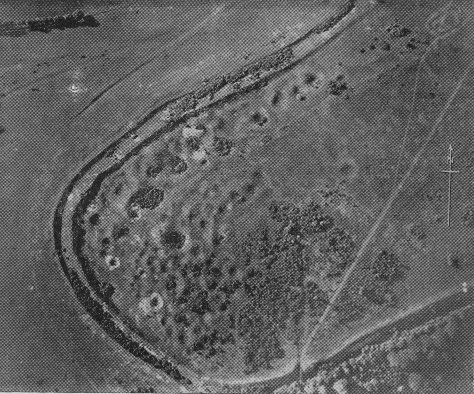
Cissbury Ring is a huge hillfort on the South Downs. The history of Cissbury is
long and grand. In the Neolithic, the hill which the hillfort surrounds was the
most important flint mining area in Sussex. In the Iron-Age, the biggest hillfort
in Sussex was constructed which was reinforced at the end of the Roman occupation
to defend against invading Saxons, who then may have used the fort to house a
mint. As with many other hillforts, Cissbury was used as a beacon site, before
being being used again for military purposes during WWII when the camp was
fortified with gun emplacements. The site eventually fell into the hands of the
National Trust, though despite this ownership, and the fact that the Ring was a
Scheduled Ancient Monument and important for its wildlife, some politicians
attempted to put a road through it, which fortunately failed. An astonishing
amount of material has been written on Cissbury and more is due in the summer of
2000 when geophysics work is due to be carried out on the inside of the camp.
|
|
| Archaeology |
|
The Neolithic And Flint Mining
As has been mentioned, the history of the hill on which Cissbury hillfort rests
begins in the Neolithic with the construction of the most important network of
flint mining tunnels in Sussex. The area of mining can be seen today as a
series of pits with a diameter between 3 and 36 metres, which form a rough
crescent within the western side of the camp and extend outside of the ramparts
slightly to the west and in a line thin line to the south. It is not entirely
certain how far the mining originally extended, as many of the shafts have
been ploughed over within the confines of the camp when it was occupied and
farmed within the Iron-Age and Romano-British periods. Nevertheless, a recent
RCHME survey suggests that the area of mining "covered a minimum of 9
hectares and consisted of at least 270 mineshafts", with many shallow
circular depressions being interpreted as mines that extend towards the centre
of the camp. Two of these depressions are very deep and appear to have been
reused as ponds rather than being ploughed over. Between the pits of the
remaining shafts are the spoil heaps and knapping floors that are the
by-products of flint tool mining and production. The spoil tends to have been
thrown downhill, with a very large heap being in evidence just outside of the
rampart on the south-west side. Before excavation, the hollows that were all
that were left of the mine shafts were thought to be the sites of "rude
huts" of the occupants of the hillfort itself, or even a series of dish
barrows, cattle pens, rubbish pits or water tanks. Just underneath the topsoil,
many of the pits contain the remains of flint-knapping, small pieces of antler
and remains of fires, suggesting the remaining pits after the shafts were
backfilled were used by the knappers as a sheltered place to perform their work.
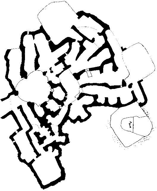
The Shafts And Galleries Of The Mines
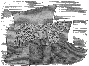
Some of the shafts were found to have been deliberately backfilled with large chalk blocks, probably as a convenient dump for waste material when the galleries around that shaft were exhausted. The shafts were cut using red deer antlers as picks and shoulder bones as shovels, cutting through layers of poor quality flint containing iron impurities to the good quality flint which can be seen at floor level in the galleries. The galleries themselves radiate out in all direction and are very small, in some cases almost too small for adults to work in. Work was difficult and unsafe in the galleries, the ceilings of which vary in height as they have collapsed in places, but average in height to about 3 feet. Some of the supporting pillars left were as small as was practical, and this practice could have led to the demise of some of the miners, whose skeletons have been found in the tunnels. The galleries connect separate shafts, which may have been open at the same time, providing multiple escape routes in case of a roof collapse and multiple sources of light to work by, though most were backfilled with chalk rubble after use to avoid having to remove it to the surface. Where the galleries do not immediately meet in passing each other, there are sometimes small windows between them, judging by their position, for some reason other than lighting, though the galleries are suprisingly light due to the reflection of sunlight on the white chalk. The entrances to the galleries from the shafts are generally smaller than the size of the galleries themselves, probably for support. These supporting entrances are also evident when the galleries open out into wide high caves which can occasionally be found where heavy excavation has taken place. The galleries tended to bend downwards by around 5° as they move towards the south edge of the hill and the shafts became more shallow at the edge as it took less digging to get down to the main seam of flints, which rises towards the north. In the deeper shafts, ledges were constructed as a halfway step to the top of the shaft.
While most of the shafts were immediately backfilled after a season of digging (the large chalk blocks had not been broken down by frost and winter weathering), there was one shaft which was clear after use or had been cleared, and showed signs of habitation. As the bottom of the pit, a gallery had been walled up and a fence of stones had been put in front to mark the bounds of a hearth. This shaft is one of the ones that the incised line were found near the gallery entrances, and it may be the case that they were made during the occupation, as the marked were made through a coating on the surface of the chalk. Some of the galleries themselves seem to have been used and their height augmented from the low crawlways constructed when the gallery was first mined for flint. After this dwelling went out of use, the shaft gradually silted up. Finds In The Flint Mines The tools use for excavation at Cissbury were mainly the antlers and shoulder-blades of red deer, used as picks and shovels respectively. Some of the flints found seem to have been adapted to be hafted into certain bones to be used as hammers and pieces of bone pierced for this function were also found. Apart from the red deer bones, the shafts and galleries at Cissbury contained a variety of bones from humans and other animals. Some of the first found were the bones of two Ox along with the bones of other animals at the bottom of the shaft. These bones were mixed in with the chalk rubble suggesting that the bones were not used for provisions in the shafts. The perfect condition of the two Ox skulls would also argue against the throwing in of the bones as rubbish along with the large blocks of chalk rubble and the throwing in of the bones and subsequent filling of the shaft with heavy blocks of chalk should have broken these bones, though this may be an indication that the flesh was still on the skulls at this point, cushioning many of the blows. Other bones include stag, otter, wild boar and roe deer. Radiocarbon dates of three antler picks have given the following results :
In one shaft, the bones of a woman were found feet to the sky, buried in rubble over two feet from the floor. How she got into this position and whether she was already dead is unknown. The body was surrounded by bones of pigs, ox, goat, fox and roe. Sixteen feet down, but not at the bottom of a shaft, a skeleton was found lying crouched on its right side facing the east and surrounded by a row of chalk blocks and large flints. This is more obviously a deliberate burial of a 25 year old male, interred with 7 flint implements, 6 behind him and a flint axe and a burnt pebble in front. The objects this man was buried with implies that he was involved in the flint mining, though it is not known how he died. The shaft was backfilled with 2 feet of rubble after the burial and objects relating to the production of flint implements were found on the post-fill surface.
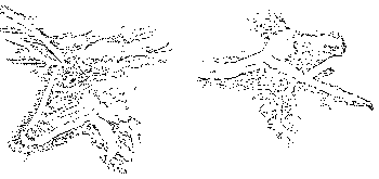
There are several chalk carvings in the galleries, first notices by Lane-Fox but also by later excavators. The most common were a series of scratches in the chalk that formed a criss-cross pattern, usually found near or over the entrances to the galleries from the shafts. Other carvings, this time on the wall of one of the galleries were of two animals, commonly interpreted as a red deer and a short horned bull (pictured below).
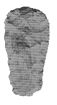
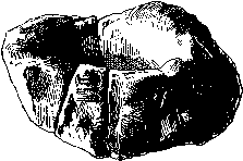
Chalk objects found include "A rude nondescript figure...cut with a flint, on a block of chalk in the rubble of the shaft..." and an object that suggests other means of illumination were used than just relying on the reflective surface of the chalk to bring light into the galleries. It has been suggested that the chalk cup shown below was used as a candle containing animal fat and a wick. Other carved chalk objects found include four pear shaped lumps pierced at one end and with signs of wear from some cord being threaded through it. These may have been used as a counterweight for some sort of pulley system to take materials and waste to the surface, though three more have been found in shallow pits on the surface near a piece of carved bone reckoned to be part of a loom, leading to the interpretation that these are loom weights. Marks similar to the criss-cross pattern found near the entrance to some galleries were also found scores on small chalk blocks.
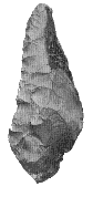
The Flint Industry At Cissbury 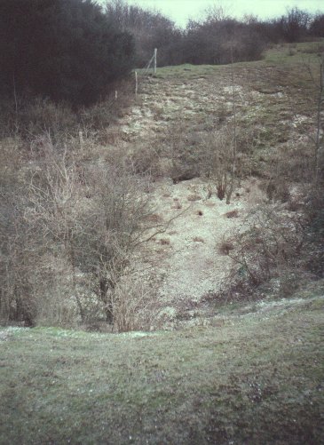 The knapping and finishing of the tools was performed on the surface and large
quantities of flint flakes can be found with little trouble. A tool used for
finishing include a piece of quartzite ground smooth on one side and used for
polishing axes. This was an isolated find though, indicating many of
the axes may have been polished elsewhere.
One of the tools used in excavation were small pieces of red-deer tine, some of
which showed signs of wear at the base where they may have been hammered into a
crack in the chalk to break it off. Holes bored into the chalk in the shafts
indicate this practice, one of them still containing the piece of tine hammered
in.
The knapping and finishing of the tools was performed on the surface and large
quantities of flint flakes can be found with little trouble. A tool used for
finishing include a piece of quartzite ground smooth on one side and used for
polishing axes. This was an isolated find though, indicating many of
the axes may have been polished elsewhere.
One of the tools used in excavation were small pieces of red-deer tine, some of
which showed signs of wear at the base where they may have been hammered into a
crack in the chalk to break it off. Holes bored into the chalk in the shafts
indicate this practice, one of them still containing the piece of tine hammered
in.
The flint works at Cissbury Ring are at the eastern end of a group of mines on the Sussex Downs that form the most important flint mining area in Britain. Six mines are known in the area, with the next along the chain at Church Hill, being just 2 miles to the west over the Findon Valley. The size and importance of the mines at Cissbury are second only to those of Grimes Graves in Norfolk. It has been suggested that it was not at all necessary to mine for flint and that flints found on the surface are perfectly good for making tools, and that around 90% of implements found are of this type. While excavated flints have not been weathered and have less internal fractures, making them a better raw material for flint tool production, the explanation given for the real purpose of taking the great trouble of excavating the flints is that the tools made with excavated flint had value for prestige purposes. A miniature flint axe found in a mole hill at Cissbury may support this. Being just 8cm long, it is difficult to see any practical value. The Iron-Age Fortifications At the beginning of the Middle Iron-Age, the fortifications that are the most conspicuous part of the site were thrown up. It was originally thought that the hillforts of Highdown and Chanctonbury Ring were outlying posts to guard the approach to Cissbury on areas of Downland not visible from the fort itself, though it is now known these two forts were actually built in the Early Iron-Age and during the Middle Iron-Age, Cissbury was the only new fort between the River Arun and the River Adur. There were fewer forts built in the Middle Iron-Age as compared to the Early Iron-Age and this is seen as a sign of changing roles for these enclosures, perhaps as community centres for a wide scatter of population.
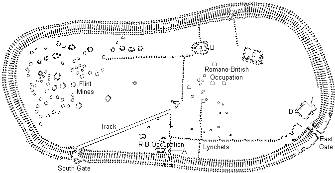
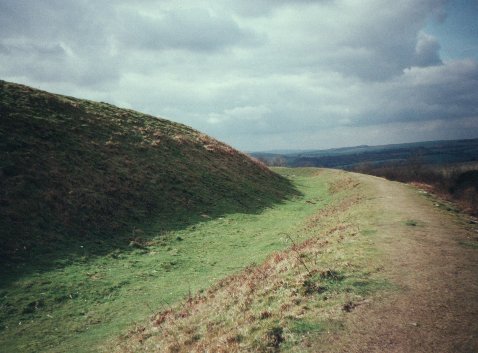
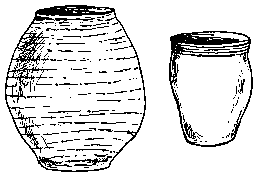
The ramparts on Cissbury follow the contour of the hill and give the fort a jelly bean shape aligned roughly ENE-WSW which surround a massive 24 hectares of land. The fort contains most of the known flint mines within its walls, but the builders were not shy about destroying the work of the neolithic cultures. As the line of the rampart crept around the crest of the hill, many pits were covered over. The rampart itself consists of a main bank with ditch on the outside with a smaller bank on the outside edge of the main ditch. The main bank is between 3-4 metres wide and stands today on average 1.3 metres in height, though where the approach to the fort is not quite as sheer as in most places, the bank rises to a height of 3.9 metres. The ditch is on average 1.9 metres deep and 5 metres wide rising to 9 metres wide around the entrances. When the ditch was originally cut, its depth was another 5 feet below the current land surface, but it has silted up over the years. From the layers of the silt can be seen that at a later time in the camps history, the camp was occupied by the Romano-British, who left sherds of their pottery there.
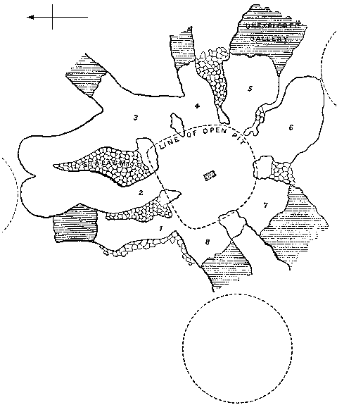
There were two original entrances on the east and south-west of the rampart. Between these on the outside can be seen the remains of celtic field systems. The secondary bank cannot be seen around the area of the entrances, leaving a much wider ditch, and it has been suggested that the outer bank in these areas were removed to reinforce the inner rampart. In addition to this, hollows on the inside of the eastern gate were probably dug to provide material to reinforce the ramparts still further. The Inside Of The Fort The vast space enclosed by the ramparts have allowed the occupants to farm the area, with lynchets spreading across the camp and encroaching on the flint mines to the west. As well as the shallow depressions left by the ploughed out flint mines near the centre of the fort, further rectangular depressions may mark the locations of Roman-British Settlement. Excavations of some of the "Buildings" within the fort have painted a quite confusing picture. The enclosure marked A on the map would appear to of Romano-Celtic form, being roughly rectangular, but it precedes a pit dug at a later date over one corner of the structure, which contained the bones of horse, kid and Ox, shellfish such as oyster, cockle and mussel, Romano-Celtic pottery and tile. Despite this, is would appear the the building went in and out of use during the same period. The building marked B on the map has an entrance to the north-west and an inner ditch enclosed within an oddly shaped bank. Finds came to nothing besides what appear to be neolithic flintwork from pits in the centre of the enclosure and the ditch. The age of the building is unknown though given the lack of any better evidence, it may be Neolithic. Building C is the largest enclosure within Cissbury Ring and has been severely damaged by cultivation and pits on its eastern side, probably from WWII. The whole is rectangular and contains at least 5 subdivisions. No finds were found in situ but the building has been interpreted as Romano-Celtic from surface scatter of pottery. The date of building D is also unknown due to lack of finds, though it is clear that it is earlier than the reinforcement of the ramparts around the entrances, as pits cut for material for this work have cut into part of this building. Most of the lynchets found within the Ring lie parallel or perpendicular to the ramparts, though it has been suggested that some of the lynchets on the north side are cut by the inner ditch, thus making the lynchets earlier than the ramparts. Actually, the plough soil built up in the angle between the slope of the hill and the rampart almost to the level of the top of the rampart, before being cut by the small inner ditch to reinforce the rampart in the area of cultivation. Most of the lynchets are in the central and eastern parts of the camp, though they do extend some way to the west where the land has been reclaimed for agriculture from the Neolithic flint mines. Saxon Mint It has been suggested that Cissbury was once the site of a Saxon mint. Coins bearing the mint signatures Sithe, Sithsteb and Sithmes have been found on coins of Ethelred II and Cnut (1009-1023) and by their distribution it is thought that they were minted in an area between Lewes and Chichester. The use of old forts for mints is not unknown, when nearby mints are moved there during dangerous times, though there has been no archaeological confirmation of the mint at Cissbury. Outside The Fort As has already been noted, the remains of the flint mines extend outside of the camp southward in a line approximately 200 metres long and west slightly can be seen the remains of refuse heaps from the workings of the mines. Further east of this, between the Southern and Eastern entrances, is a network of field systems, which extend Southwards onto Vineyard Hill. There is a small scatter of barrows around the camp, one to the west, one to the south near the bottom of Vineyard Hill and one to the east, just south of the ancient trackway. It is known that during excavations in the early days of antiquarian interest, two Early Bronze Age Beakers were found in a barrow near Cissbury, though it is not recorded from which one.
Cissbury Ring sits between the parishes of Findon and Durrington with the line of the parish boundary currently running east west and curving north around the camp when it hits it. The line of the boundary follows the ancient track that leads east out of the camp to a point where it splits north towards the Iron-Age settlement at Park Brow and south towards Broadwater. This north-south track also marks the end of the Findon and Durrington parishes and the beginning of the Sompting Parish. Dating Evidence Dating material for the Romano-British period is quite common with large quantities of oyster shells, popular in Roman Britain, along with some Romano-British pottery. These items are generally found in the upper fill layers of pits, lynchets and ditches, with the lower layers being populated by Iron-Age pottery, sea pebbles uses as sling stones, and sea-mussels more popular during the Iron-Age. The pottery suggests the fort was built at the beginning of the Middle Iron-Age (La Tene), with possible pre-fort activity in the Early Iron-Age and continuation of use through the Late Iron-Age. Despite the date for the building of the camp, there is a great amount of evidence for use of the camp within Romano-British times. Apart from the Oyster shells and pottery, rabbits have dug up tesserae within the centre of Cissbury, indicating an important Roman building, while the coins found suggest several centuries of use. Wealth existed here also, a brass ring holding an opal from the 4th century was found just within the eastern entrance. The RHCME survey found a large quantity of rectangular enclosures which were probably from the Roman period, one of these being cut by pits used to provide material for reinforcing the ramparts. The fort probably went out of use with the coming of the Saxons, and though it has been suggested by numismatists that there may have been a Saxon mint at Cissbury, no archaeological evidence has yet been found of this. Pits For Ritual Deposition There are many pits on Cissbury from many different ages. One in particular, excavated by E.C. Curwen on the North-East edge of the camp underneath the inner ditch (dug into plough soil) is interesting for its contents. Dating to the middle of the Middle Iron Age, the pit was dug over 4 feet into solid chalk and contained pottery, 2 chalk loom weights, an iron knife, an iron rod, a piece of bronze (perhaps from a scabbard), a perforated clay brick vitrified on one side, 404 beach pebbles used for sling stones, animal bones and a water worn oyster shell. The excavators thought the pit to be a storage pit, but why store a worn oyster shell and bones. Equally it can't be a rubbish pit, why throw away an unbroken iron knife that is probably quite valuable and the unbroken loom weights. One solution to this problem is to look at it in the same way as the Pits at Mount Caburn where it has been suggested that the large quantity of pits and their contents represent some form of ritual deposition. Certainly the two camps are contemporary and the occupants may have shared a belief system that would have made the digging of their pits possible. At the other end of the Ring, further pits excavated around the area of flint mining are not so decisive in their contents, containing mainly occupation rubbish, including fragments of wattle & daub and animal bones which are believed to have been discarded whilst still covered in flesh due to the consistency of the soil surrounding them. Nevertheless the contents of these western pits bear a distinct similarity to those at Mount Caburn and the small quantity of items found may argue against a pit constructed deliberately for rubbish. History Of The Excavations Though Cissbury has been under historic scrutiny as far back as the late 18th century when Camden's Britannia described the earthworks, it wasn't until the mid 19th century that the Ring was first excavated by George Irving. His excavations weren't extensive or particularly fruitful as far as dating evidence was concerned and he concluded, incorrectly, that the Ring was built by the Romans. Next came Mr. Lane-Fox who in the 1860's correctly identified the large pits as Neolithic flint works, but mistook the hard packed backfill of the shafts for the original surface, finding only evidence of fires and flint axe production from after the shaft had been filled and the remaining basin shaped hollow used as shelter for the flint knappers. He also made the mistake of thinking the ramparts were of the same period as the flint mines. In 1874, Shortly after the flint mines at Grimes Graves were excavated and seen for what they were, Cissbury was visited by Ernest Willett who found the true nature of the shafts. This quickly provoked a rash of excavations headed by the return of Mr. Lane-Fox followed by Mr. Park-Harrison, who both excavated a large number of the mine shafts and reported their findings in the Journal of the Anthropological Institute. Some of the flint mining shafts were found underneath the ramparts, proving for the first time that the ramparts were of a later date than the mines. Further work on dating the phases of the camp was carried out by one of the Curwen's and published in 1931. The ramparts and field systems were excavated to show the sequence of occupation. Further excavations of the flint mines by John Pull followed in the 1950's but as the site is a scheduled ancient monument that is not in any danger, no excavation has taken place since, though a very thorough survey was carried out by the RHCME and published in 1994. |
|
| Folklore |
|
Serpents & Treasure
Below Cissbury, there is said to be a tunnel which leads to Offington Hall near
Salvington to the south. The story goes that owner of Offington Hall had heard a
rumour that there was Buried Treasure in the tunnel
and offered half the money to anyone who could find it. Unfortunately several
people, whilst digging, were driven away by large Serpents.
UFO's The Ring of Cissbury has been associated with UFO's after several have been seen moving from Cissbury towards Chanctonbury Ring to the north. One example of this phenomenon occurred on 23rd August 1975 when a bright orange object was seen over Cissbury Ring. The object hovered briefly before shooting off in the direction of Chanctonbury, where it was seen by an old woman walking her dog, who saw a : "large, saucer-shaped, bright orange object land on the west side of Chanctonbury Hill". This is typical of the sightings, where the UFO is seen at Cissbury before it moves towards Chanctonbury Ring, where it is seen again by another witness. The Devil In one of the most geographically spaced pieces of folklore in Sussex, The Devil is named as the creator of Cissbury Ring. Whilst digging Devil's Dyke, he threw clods of earth around which when they landed, created various earthworks in Sussex including Cissbury Ring, Rackham Hill, Chanctonbury Ring and Mount Caburn. Cæser The other creative force, named for the building of the fort by the local population was Cæser himself. Whether this is true folk memory of the later Roman occupation of the fort or an interpretation of the name of the fort is unknown, though in 1663 the fort was noted as being called "Cesars Bury". Fairies Midsummer eve is noted as a time when fairies are abroad. At Cissbury, as at other earthworks in Sussex such as Tarberry Hill and Harrow Hill, it is said you can see the fairies dancing at this time. It is worth noting that on the coins attributed to an alleged Saxon Mint on Cissbury is stamped variations on the name "Sithe", which is also one of the Irish names for a fairy. Could Cissbury be a fairy hill (Sithesbury)? It is unlikely as the word Sithe is Celtic and Burh is Saxon, but interesting nevertheless. |
|
| Ghosts |
|
Highwayman
Near Cissbury Ring, a highwayman was executed for his crimes. Before he died,
he swore that he would never rest. He was buried in the middle of the road, but
his corpse was later found above ground and took several attempts to bury before
he stayed put. After that, he still didn't rest and his ghostly form was seen
riding a horse on the highway where he was buried. A coach driver decided to
run down the thief but he passed straight through the coach. Cart drivers taking
the road would go over something large but looking back would see nothing.
|
|
| Earth Mysteries |
|
Alignments
The folklore of the tunnel between Offington Hall and Cissbury is particularly
interesting in that it reveals an alignment of sites including the two already
mentioned plus two churches. Though Offington Hall is long gone, it can be seen
on the first edition OS maps at approximately TQ134051.
Crop Circles The area around Cissbury Ring is popular with the Sussex crop circle fraternity. Apart from being the scene of some of the counties most beautiful and striking crop circles, the area was believed to be the source of earth energies which produced many of the the crop circles in the area, particularly at Sompting just to the south-east which is a crop circle hot spot in Sussex. From 1993, Cissbury itself became the focus of a strange set of rituals performed by a local Crop Circle society called Southern Circular Research who were trying to stimulate the production of crop circles. With the aid of a psychic called Paul Bura, the group attempted to communicate with beings who guarded the Ring and persuade them to help in the quest to video the formation of a crop circle. The group found three such guardians called "Emun", "Rachael" and "Tryst", and were told that the Ring represented the torso of a naked woman and at her navel, there once stood a large standing stone which was later replaced by a Roman temple to Diana. The full story can be found in 'Quest for Contact'.
|
|
| Resources |
|
Cissbury Ring Index at Findon Village Antiquities Cissbury Ring at The Historic Village of Findon |
|
| Bibliography |
|
Allcroft, A.H. : Earthwork of England, Macmillan 1908 Barber, Martyn et al. : The Neolithic Flint Mines of England, English Heritage 1999 Clinch, George : Early Man, VCH Vol. 1 (309-332) 1973 Clinch, George : Ancient Earthworks, VCH Vol. 1 (435-480) 1973 Coates, Richard : Studies and Observations in Sussex Place Names, SAC Vol.118 (309-329) 1980 Curwen, E. : Some Roman Antiquities..., SAC Vol. 63 (220-221) 1922 Curwen, E. Cecil : Prehistoric Sussex, Homeland Association Ltd. 1929 Curwen, E. Cecil : The Date of Cissbury Camp, Ant. J. Vol. 11 (pt. 3) 1931 Curwen, E. Cecil : A Saxon Mint at Cissbury?, SNQ Vol. 15 (134-135) Donachie, J.D. & Field, D.J. : Cissbury Ring: A Survey by the RCHME, SAC Vol. 132 (25-32) 1994 Ed. Mawer, A. & Stenton, F.M. : The Place Names of Sussex (Parts I & II), Cam. UP 1929 Field, David : Miniature flint axe from Cissbury, SAC Vol. 120 (205-207) 1982 Frost, Marian : The Early History of Worthing, Combridges 1929 Glover, Judith : Sussex Place Names, Countryside Books 1997 Grinsell, L.V. : Sussex in the Bronze Age, SAC Vol. 72 (30-68) 1931 Hamilton, S & Manley, J : Points of View : Prominent Enclosures..., SAC Vol. 135 (93-112) 1997 Park-Harrison, J. : Report on some Further Discoveries at Cissbury, J. of the Royal Anth. Inst. Vol. 6 (430-442) 1877 Park-Harrison, J. : Additional Discoveries at Cissbury, J. of the Royal Anth. Inst. Vol. 7 (412-433) 1878 Holgate, Robin : Prehistoric Flint Mines, Shire Publications 1991 Hudson, T.P. : The place-name 'Cissbury', SAC Vol. 120 (231) 1982 Irving, George Vere : On the Camps at Cissbury, Sussex, J. of the British Arch. Assoc. Vol. 13 (1st series) 1857 Lane-Fox, A.H. : Further remarks on the Hill Forts of Sussex, Archaeologia Vol. 42 (53-76) 1869 Lane-Fox, A.H. : Excavations at Cissbury Camp, J. of the Royal Anth. Inst. Vol. 5 (357-390) 1876 Newton, Toyne : Where Dark Forces Meet, The Unexplained 77 (1548-1540) Simpson, Jacqueline : The Folklore Of Sussex, B. T. Batsford Ltd. 1973 Smith, R.A. : On the Date of Grime's Graves and Cissbury Flint-mines, Archaeologia Vol. 63 1912 Stevens, Joseph : The Flint-Works at Cissbury, SAC Vol. 24 (145-165) 1872 Thomas, Andy : Fields Of Mystery, S.B. Publications 1996 Thomas, Andy : Quest For Contact, S.B. Publications 1997 Toms, H.S. : The Ancient Hill-Fort at Cissbury, SCM Vol. 1, No. 8 1927 Toms, H.S. : Ancient Ponds Near Cissbury, SCM Vol. 1, No. 9 1927 Toms, H.S. : The Cissbury Earthworks, SAC Vol. 67 (55-83) 1926 Turner, Edward : Military Earthworks of the Southdowns, SAC Vol. 3 (173-184) 1850 Wales, Tony : Sussex Ghosts & Legends, Countryside Books 1992 Willet, E.H. : On Flint Workings at Cissbury, Sussex, Archaeologia Vol. 45 (337-348) 1875 Wyatt, H.R.P : Beaker Found at Worthing, SAC Vol. 68 (277) 1927 |
[ Sussex Main Page ]