| Philpots Promontory Camp |
| Map Ref : TQ350323 |
| Subject List | Archaeology |
|---|---|
[ Sussex Main Page ]
|
|
| Name Derivation |
|
PHILPOTS : From John Philpot of Horsted Keynes (1327) Prev. Barleylands before above. CHIDDINGLY WOOD : From Leah (Woodland Clearing) belonging to people of Citta (Saxon Name) Orig. Citangaleahge (765), then Chytinglegh (1288), then Little Chittinglye Note: Tribal name perhaps also relates to Chithurst, Chitcombe and Chiddingly. A.J.C Hare in 1894 describes the wood as being called Andreds Wood, probably as part of the great wealden forest of Andred. |
|
| History |
|
Introduction
In the High Weald, between Wakehurst Place and West Hoathly, is a natural
sandstone outcropping in the shape of a V. This outcropping and the raised area
within it were used during the Iron-Age as a fort and the site as a whole is
known as Philpots Promontory Camp. The camp itself is on private land, owned by
three seperate estates including the Stonelands Estate to the north. There are
springs at the site and due to the dampness of the area as a whole, the site is
home to many rare ferns and lichens growing on the rock outcrops, which has given
rise to the site being awarded the status of an SSSI. Peter Brandon has tentatively
linked the name Welinga Stane (the stone of the stream dwellers) in an
Anglo-Saxon land charter of 765 to the stone known as Big-Upon-Little on this
site.
|
|
| Archaeology |
|
The Fort
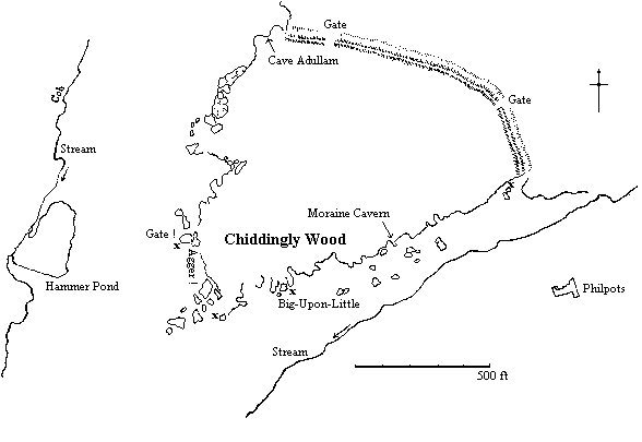
Philpots Promontory Camp lies just north of Ardingly in the parish of West
Hoathly and is triangular in shape, two sides being formed of two natural
sandstone cliffs between 15 and 30 feet high, the third being bounded by a
vallum and fosse of uncertain age. There are apparently two gates in the vallum,
the fosse never having been dug out, though no post holes could be found during
excavation, though that could be due to the nature of the soil which holds less
over the years than the chalk of the downs. The east gate has recently been
enlarged to allow access into the camp for carts, since the camp itself now has
an agricultural use. There is a possible third gate on the western sandstone
cliffs which seems to be gate like only through it's current state of access
rather than by any archaeological evidence.
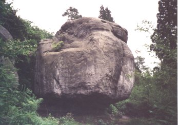
Archaeological Finds Indeed there is very little in the way of archeological evidence apart from the earthwork itself. There is evidence of flint knapping in the camp, most of the flakes being found on the surface with some being buried at the bottom of the fosse. The knapping seems to be of a lower quality to that seen on the downs, though quite similar to some found near Balcombe a few miles to the west. Small quantities were found near what is supposed to be the gate in the sandstone cliff, at the base of the cliff at the eastern end of the vallum above and at the tip of the fort where the two cliff faces meet. Most of the flints though were found at a large rock variously called "Great-Upon-Little" or "Big-Upon-Little", from which the name of an area called "Stonelands" just to the north probably takes it's name. Some flint flakes from near one of the caves have been described as Mesolithic, in common with finds from other rock outcroppings in the area. Inside the camp, a Mesolithic Tranchet arrow-head was found. Many flints from the Mesolithic and Neolithic have been found in rock outcroppings in the Weald, but pottery from this period is very rare as it doesn't survive well in the soil conditions.
Geology Before this stone is described, it might be worth explaining the geology that caused it. The sandstone cliffs that form the greater part of the camp are not uniform. The upper part of the cliffs are of a hard sandstone that is suitable for use in building. The lower part is far softer and is very wet due to the level of the water table being higher than the base of the cliffs. The sandstone also has a tendancy to split vertically, causing caves and narrow paths between the rocks. There are two valleys either side still containing streams, one being used for a hammer pond, and springs lower down the hill. The combination of these factors has caused the above named stone to form. It is a large block of sandstone separate from the main cliffs, with the soft layer underneath worn away to a thin shaft. Imagine a stone from a road runner cartoon, though some early observers seemed to think the edifice was one separate stone balanced upon another and this is probably where the stone got it's name. Big-Upon-Little The stone was a great attraction for tourists at some point and there are initials carved wherever a hand could reach, dating anywhere from the 17th century, with initials being carved over others and the effects of the weather leaving the possibility of earlier dates, indeed Thomas Pownall in 1778 tell us that the stone "was covered with multitudes of names and initials of all dates". The top of the rock next to it is easily accessible allowing the brave to jump across to the top of Big-Upon-Little. The author of this page found copper coins left there like some sort of votive offering. Though Big-Upon-Little is the most famous in the camp, it is not the only marked stone. Another Carved Stone 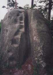 The stone pictured here, just west of Big-Upon-Little has obvious symbolism in
it's carving. Apart from being told the name of the stone, which is called
Executioners Rock, there is no documentation relating to this stone that this
author can find, it might well be a representation of the female genitalia, it
might well be a relic from the tourists that visited, or as the name suggests, a
grisley site of execution. On the one hand there is the well worn steps up to
the top that suggest the passage of tourists to the top, on the other hand, why
would such tourists carve something that would take up so much time and yet be
so anonymous, unlike the ubiquitous initials on Big-Upon-Little itself. There
are no initials on this stone. The locals say the area around Big-Upon-Little
was used for pagan sacrifice, probably to please the tourists and probably
improbable, though looking at this stone it easy to see a channel for blood.
The stone pictured here, just west of Big-Upon-Little has obvious symbolism in
it's carving. Apart from being told the name of the stone, which is called
Executioners Rock, there is no documentation relating to this stone that this
author can find, it might well be a representation of the female genitalia, it
might well be a relic from the tourists that visited, or as the name suggests, a
grisley site of execution. On the one hand there is the well worn steps up to
the top that suggest the passage of tourists to the top, on the other hand, why
would such tourists carve something that would take up so much time and yet be
so anonymous, unlike the ubiquitous initials on Big-Upon-Little itself. There
are no initials on this stone. The locals say the area around Big-Upon-Little
was used for pagan sacrifice, probably to please the tourists and probably
improbable, though looking at this stone it easy to see a channel for blood.
| |
|
Caves
The last features of this site worthy of mention are two caves called "Cave
Adullam" (dated 1760) and "Moraine Cavern" (dated 1859), the names
taken from inscriptions within the caves themselves. Moraine Cavern contains two
carvings resembling Celtic knotwork, which were carved in the early 20th
century by some members of a boys club. Mesolithic flint flakes and an arrowhead
have been found in the caves.
Conclusion The previous use of the site as a whole still lies in mystery though some explanations have been put forward. The lack of finds might suggest a use as an animal pen, to keep a herd safe from the wolves of the surrounding weald. The same Wealden connection also suggests a safe place for refugees fleeing from Saxon invaders. The general lack of finds would indicate a temporary residence. The site was certainly used in the Mesolithic, and perhaps in the Neolithic as well. |
|
| Ghosts |
|
Black Dogs
Ghosts of Black Dogs aren't restricted to the South
Downs, a poacher in the area has said : "There's one thing I dare not do;
I'd be afear'd to walk through that girt valley below Big-On-Little after dark.
It's a terrible ellynge place and a gurt black ghost hound walks there o'nights".
The hound is called "Gytrack" and Ellynge is a local Sussex word for
eerie. Ian Hannah notes that the valley "seems to have no name (except that
it is locally known as the Grattack, after a dog)".
To add to the bad reputation of the place, a writer in the journal Folklore notes : "A man of 84 years of age told me that he had seen a book which told all about the rock called Great-upon-Little, but that it did not mention what he had heard people say, that the rock had formerly been an object of worship, and that to touch it was death." |
|
| Bibliography |
|
Brandon, P. : The Sussex Landscape, Hodder & Stoughton 1974 Curwen, E. & E.C. : Two Wealden Promontory Forts, SAC Vol. 66 (176-180) 1925 Hannah, I.C. : Philpots Camp, West Hoathly, SAC Vol. 73 (156-167) 1932 Holgate, Mary S. : The Surroundings of Philpots Camp, SAC Vol. 67 (222-224) 1926 Holliwell, L.R. : South-East England, Climbers Club 1969 Mawer, A. & Stenton, F.M. : The Place Names of Sussex (Parts I & II), Cam. UP 1929 Money, J.H. : Excavations at High Rocks, Tunbridge Wells, 1954-1956, SAC Vol. 98 1960 Tebbutt, C.F. : Carvings on the Rocks in the Chiddingly Woods, SNQ Vol. 17, No. 6 1970 Tebbutt, C.F. : The Prehistoric Occupation of the Ashdown Forest Area of the Weald, SAC Vol. 112 1974 Unknown : Collectanea, Folklore Vol. 26 1915 |
[ Sussex Main Page ]