Setting Up A Geophysics Grid

Page Index

[ Archaeological Geophysics Page ]

The Purpose Of Setting Up A Grid

When taking a reading using a piece of geophysics equipment, you are getting a response from a single point on the landscape. Whilst this is meaningful, in itself it is a useless piece of information. Geophysics surveys work by comparing readings from one area with another, so patterns can be recognised. The best way to do this is to take readings at regular intervals, which can then be displayed on a computer. Whilst it is possible to measure out where every single reading should go for a survey, this would be horribly time consuming, so the best way is to have a set of large squares which are subdivided by a series of marked strings when the survey takes place. The size of the squares that make up the survey area is important. Too small and you spend too long setting up the squares, too big and performing the survey itself becomes a problem. Resistivity meters have a cable, so if the squares are too big then the cable gets stretched. Magnetometers do not suffer from this restriction, so larger grid squares can be used. For resistivity, most people tend to use 20mx20m grids, though for magnetometry, 30mx30m and even 40mx40m grids are not uncommon. The choice is up to you and most hardware and software will cope with a variety of grid sizes.

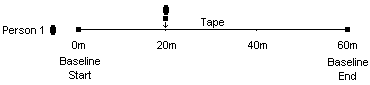
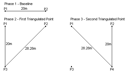
It is important that when you set up a grid for a survey, that you can set out the same grid again. This is so you you know exactly where on your site the new features are and can tell people where they should be excavating. The best way to do this is to set up a baseline. If you can find two points that can be found again be referencing them to fixed points in the landscape, you can draw a line between them and offset your grids from this line. The fixed points can be anything that is fixed in the landscape and is unlikely to be moved. You need two of these features for each point. If you measure from the point on the end of your baseline to each of the fixed points, you will be able to triangulate back from the two fixed points back to the baseline point using the measurements you have recorded. Whilst it is desirable to have the length of the baseline equal to the length of the survey area, it is not always possible, so you must record how far along the baseline the survey area begins. The baseline itself can be positioned anywhere you wish, but there are certain constraints, such as availability of fixed points to reference from. Generally, you should set up your baseline in such a way that the grid squares will not conflict with the boundaries of the site and cause disruption to the survey.

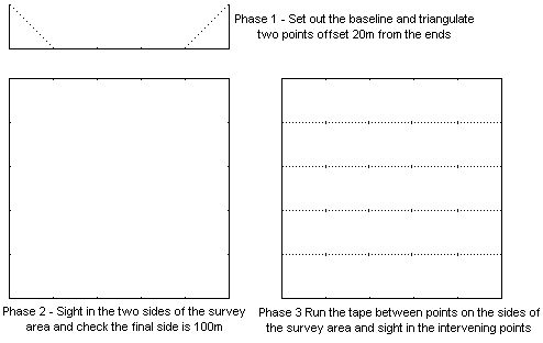
Once you have set up your baseline, the grid squares themselves can be offset from it. There are several methods, described below. Whatever method you use, a quick sketch of the baseline, grids, local features and any relevant measurements should be made for your records, so the grids can be reconstructed as necessary. Notes relevant to the processing of data should also be made, such as the direction of survey within a grid and the order in which the grid squares are surveyed.

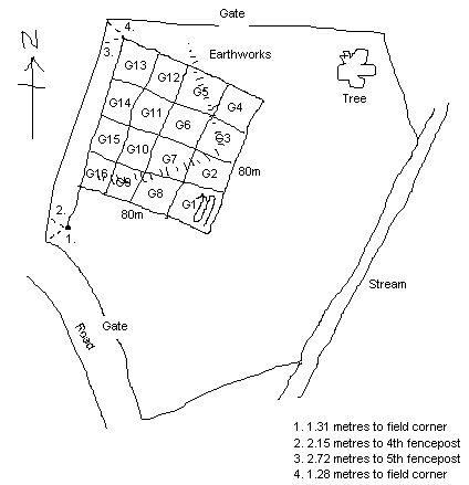
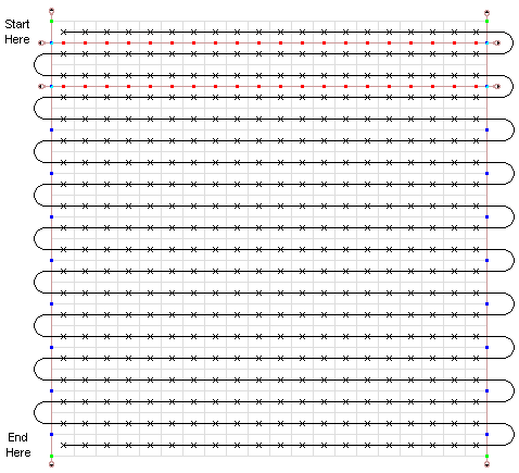
An Example Sketch For Geophysics Records


Setting Up A Grid Using Tapes

Unless you have a large amount of money, you will be probably setting up your grids using tapes, usually a combination of 30 metre and 100 metre tapes. You will also need a quantity of ranging poles or bamboo canes topped with colourful tape for visibility. Canes are lighter if you have to carry them to the survey area but harder to see and push into the ground. They can also be somewhat less than straight, which can cause problems described later. There are two main processes involved in setting up a grid using tapes, the first is sighting and measuring and the second is triangulation.

To set up your baseline in the first place, you will need to use sighting and measuring. Assuming you are going to be making your baseline the same length as your survey area, you will need to choose a starting point and then measure using a suitably long tape the distance of your survey to the end point of the baseline. If the baseline is constrained by a factor other than the survey area then you will have to pick the two points and measure to the survey area. Most importantly, your baseline should be straight, and you can do this by sighting in the points using tapes and ranging poles or bamboo canes.

If you have points on your baseline and you want to set up the intervening points, then start by placing two ranging poles in the ground at these end points. With a tape running in between these two poles, set up poles at the required distance in between. With one person holding these new poles, another person can stand at one end of the baseline and instruct the first person to move the pole until it is in line with the two poles at the ends of the baseline. Errors can creep in here, usually because the poles are not upright or in the case of bamboo canes, because the canes themselves are not straight.

Setting Up A Baseline


Once you have set up your baseline, you can now set up the grid squares, and here we need a little bit of maths. If you can remember your maths lessons at school, you may remember that when dealing with right angle triangles, the sum of the hypotenuse is equal to the sum of the squares of the other two sides. Basically, if you want to set up a square from two points you can make two right angle triangles using tapes to get the other two points. If you don't want to do the maths, all that you have to remember are the diagonals for the three most common squares used in geophysics :

  • 10m Square: 14.14m
  • 20m Square: 28.28m
  • 30m Square: 42.43m
  • 40m Square: 56.57m
Using two tapes, a square can be set up from a baseline or another two adjacent points in two stages, as shown below. It should be noted here that this method can produce cumulative errors, so when triangulating to a new point, you should always use the oldest adjacent points available to you. When you have set up a point, and if there are other suitable points available, the new point can be checked by looking to see if it is line with two or more already existing points. Errors can be caused by vegetation or other terrain getting in the way, or by the slope of a hill. Whilst this method is useful for small surveys, larger surveys need something that has less cumulative errors.

Setting Up A Square Using Triangulation

If you are surveying a very large area, a quicker and more accurate way to set up a grid is using the a combination of the sighting method used for the baseline and the triangulation method shown above. Say you have a hundred metre tape and want to set up an area 100 metres square containing 25 grid squares of 20x20m each for surveying. Additionally to your 100m tape, you will need a thirty metre tape. First of all, set out a baseline of 100m using the sighting method. At the ends of this baseline, use triangulation to set up two points offset 20 metres from the baseline. With these two additional points, you can now use sighting again to set up the two sides of your 100x100m survey area. When you have these two lines, you can check they are correct by measuring between the ends to make sure the last side is also 100m. The first time I was shown this I thought it would be very inaccurate, but the error on the last side was only 7cm over 100m, which is perfectly acceptable. Finally, you can set up all of the points within the survey area by running the 100m tape between all points on both sides and sighting them in between the two ends.

Setting Up A Large Survey Area Using Sighting


Price: Dead cheap

Setting Up A Grid Using A Total Station

There are other faster choices if you have money. The cheaper of the two options is to use a total station. A total station is a combination of an electronic theodolite to measure angles with an Electronic Distance Measure (EDM) that bounces a laser off of a prism mounted on a staff to measure distance. This combination of the ability to measure angles and distance combined with some internal hardware to do the calculations for you gives you a system that can give you coordinates for points on the landscape. Since these machines can measure coordinates in three dimensions, they do not suffer from the same errors as tapes do, caused by measuring a line down a slope, but errors can creep in if the machine is not correctly balanced, or the operator holding the prism staff does not hold it vertical. You need two people for a total station, one to operation the machine and one to hold the staff with the prism on top, but some modern systems are robotic and only require one person to operate.

The total station knows nothing about existing coordinate systems, it only works with whatever coordinates that you give it, so unless you have access to pre-surveyed points, you will have to use an arbitrary grid. The total station can be set up on the baseline and set up so that the axis of the coordinate system on the machine is aligned along it. After that it is a simple matter to set up the other grids by using trial and error until you find the correct coordinates for the grid you want to set up. The position of the baseline in the field can be recorded by measuring the grid you have set up along with two fixed points anywhere in the field which you can come back to. These are known as resection points. When returning, you can then set up the total station anywhere in the field, measure the two resection points again, telling the machine what their coordinates were, and the machine will work out where in the field it is. It is then just a matter of laying out the grids again in the same manner as before. For display purposes, you can also measure the edge of the field or area you are working in, which can also give you a rough idea of absoulte position if you then align that field edge to a map using GIS.

Price: A second hand setup is within reach of an average local archaeological society. As they are going out of fashion, good cheap machines can be bought on ebay, but robotic total stations are still expensive.

Setting Up A Grid Using A Global Positioning System

If you have more money than sense then by far the quickest and easiest means of setting up a survey grid is using Global Positioning System. The benefit over the total station is that you will get absolute coordinates, rather than using an arbitrary grid. Unfortunately the cheap consumer level GPS systems favoured by ramblers are currently too inaccurate for the purpose of setting up a grid, as they are only accurate to about 5 metres. Survey grade equipment is needed, which will include a 'base station' and a 'rover'. The rover is the GPS which you are using to take measurements across the area you are surveying. The base station is simply a GPS unit in itself, just like the rover. It is set up nearby, and over the course of about half an hour, will work out its position very accurately. Because you don't want to be waiting that long to take a reading, the base station will send information on current errors in the satellite signals to the rover, which will apply those corrections to give an instant and accurate measurement. It is a one man operation, but if you are in a built up area, you will need someone to look after the base station, to stop it getting stolen.

A more modern system does away with the base station. The rover will contain a sim card, much like a mobile phone, with which it can connect to a service which has access to a number of base stations around the country. It will receive corrections from these base stations, but not quite in the same way as from a single base station on site. Because the base stations are some distance from you, the corrections, if applied directly, would not be that accurate. To get around this, the system builds a model of the atmospheric errors using the array of base stations, and can use this to calculate more accurate corrections at any given point within the network. Whilst the initial cost is less because you don't need to buy a base station, there is usually a very expensive subscription charge to use the network.

Price: Ka-ching, Way too much wonga to contemplate.

Survey Lines

Now we get down to what happens inside one of our grid squares. The object is to take readings at a regular interval, usually every metre for resistance. The best way to accomplish this is to have a set of strings marked up with paint, which we can set out within the grid square and use to tell us where to take the readings. Tapes are not really suitable as you keep having to look for the point you want, which slows you down. There are various ways to mark and use your strings, the first one is used for resistivity. You will need a minimum of three of these marked strings, though four is better, for reasons which will be explained later. This example assumes a grid size of 20 metres, which is standard for resistance surveys.

The first two strings go between the corners of the grid square, on opposite sides. Different colours are needed here to mark up the strings. Firstly, you will need a mark near either end of the strings, 20 metres apart, to show where the string should be placed on the corners of the grid square. Secondly, a series of marks in a different colour to show where the second set of strings should be placed. You will need one of these marks 1 metre in from each of the original end marks, then every two metres.

The second set of strings are placed between the marks on the original two strings on either side of the grid. Firstly, as before, you will need marks of one colour 20 metres apart, which will be placed on the marks on the original strings. Secondly, a set of marks in another colour to show you where to take a reading with your equipment. If you are taking a reading every metre, then these marks start half a metres in and then every one metre after that.

This will give you a set of strings that will show you where to take your readings. You do not however take a reading on the string itself, you take the reading next to the string, up one side of the string and back down the other. By doing this, we can take two lines worth of readings without moving the string, which saves time. Having two strings going across the grid means the equipment operator can start on the next string whilst the first string is being moved to a new position. Loops at the ends of the strings, past the points marking the 20 metres allow you to use pegs to fix the strings on the ground. Plastic pegs are best as they wont interfere with magnetometry equipment.

The Use Of Strings In A 20 Metre Grid


The second set of strings I will talk about here are for magnetometry. With magnetometry, you are not placing probes in the ground at a certain point, but you are walking to a set pace using a set of beeps from the machine, which you should time to match point marked on your lines. The lines between the corners of the grids will stay the same as for resistivity. The beeps will match points along the line at every metre, but these will not start half a metre out like with resistivity. The first beep will be at the start of the line, with subsequent beeps every metre after that, so the lines should be marked accordingly. The sensor column is held half a metre from the line as you walk along it, so that the readings are taken in the centre of the one metre squares. Magnetometry is also usually done using 30 or 40 metre grids, rather than the 20 metres used for resistivity.

[ Archaeological Geophysics Page ]